
Always remember to visit the National Weather Service website for up-to-date official information.
Here are the particulars of this forecast as laid out by the National Weather Service:
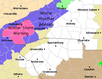
I have marked on the map so you can see what color means what on the NWS map (they keep changing the colors, so it can get confusing if you don't visit their website everyday).
Right now, Graham, Swain, Macon, Haywood and Northern Jackson Counties are under a Winter Storm Warning, and most of the rest (except Henderson, Polk and Rutherfordton) are under a Winter Weather Advisory.
Here is a map of the expected accumulations from this storm:
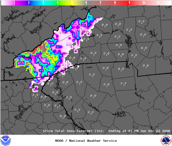
Not much to get worked up about, eh? click here for larger version
Here are the texts of the statements issued by the NWS:
A WINTER STORM WARNING REMAINS IN EFFECT UNTIL 12 PM EST TUESDAY.
SNOW SHOWERS WILL CONTINUE TO DEVELOP AND SPREAD ACROSS THE MOUNTAINS TODAY. SNOW SHOWERS WILL BECOME HEAVY AT TIMES ACROSS MOST OF THE WARNING AREA TODAY...BUT SNOW MAY MIX WITH RAIN IN LOWER MOUNTAIN VALLEYS. TEMPERATURES WILL COOL EVEN MORE TONIGHT SO BY THE TIME SNOW TAPERS OFF TUESDAY MORNING...SNOWFALL TOTALS OF 3 TO 6 INCHES ARE EXPECTED...WITH 1 TO 2 INCHES IN THE LOWER VALLEYS...AND 6 TO 8 INCHES ALONG SOME OF THE RIDGE TOPS.A WINTER STORM WARNING FOR HEAVY SNOW MEANS SEVERE WINTER WEATHER CONDITIONS ARE EXPECTED OR OCCURRING. SIGNIFICANT AMOUNTS OF SNOW ARE FORECAST THAT WILL MAKE TRAVEL DANGEROUS. ONLY TRAVEL IN AN EMERGENCY. IF YOU MUST TRAVEL...KEEP AN EXTRA FLASHLIGHT...FOOD...AND WATER IN YOUR VEHICLE IN CASE OF AN EMERGENCY.
And here is the Winter Weather Advisory:
A WINTER WEATHER ADVISORY REMAINS IN EFFECT UNTIL 12 PM EST TUESDAY.
SNOW SHOWERS WILL CONTINUE TO DEVELOP AND SPREAD ACROSS THE MOUNTAINS TODAY...MAINLY AT ELEVATIONS ABOVE 3000 FEET. SNOW THAT DOES OCCUR IN LOWER VALLEYS WILL LIKELY MIX WITH AND TURN TO RAIN DURING THE DAY. TEMPERATURES WILL COOL AGAIN TONIGHT WITH SNOW LEVELS LOWERING...SO BY THE TIME SNOW TAPERS OFF TUESDAY MORNING...TOTAL ACCUMULATIONS OF 1 TO 3 INCHES ARE EXPECTED ACROSS THE ADVISORY AREA...WITH ISOLATED 4 INCH TOTALS BY THE TIME SNOW TAPERS OFF TUESDAY MORNING.A WINTER WEATHER ADVISORY FOR SNOW MEANS THAT PERIODS OF SNOW WILL CAUSE PRIMARILY TRAVEL DIFFICULTIES. BE PREPARED FOR SNOW COVERED ROADS AND LIMITED VISIBILITIES...AND USE CAUTION WHILE DRIVING.


Post a Comment