
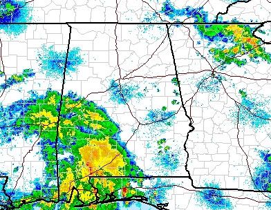
Today: A chance of showers, then showers and possibly a thunderstorm after 8am. High near 79. Calm wind becoming southeast around 5 mph. Chance of precipitation is 80%. New rainfall amounts between a quarter and half of an inch possible.
Tonight: Showers and possibly a thunderstorm. Low around 66. Calm wind becoming east around 5 mph. Chance of precipitation is 80%. New rainfall amounts between two and three inches possible.
Tuesday: Showers likely and possibly a thunderstorm. Cloudy, with a high near 75. East wind between 5 and 14 mph. Chance of precipitation is 70%. New rainfall amounts between two and three inches possible.
Tuesday Night: Showers likely and possibly a thunderstorm. Cloudy, with a low around 67. Southeast wind around 16 mph. Chance of precipitation is 70%. New rainfall amounts between one and two inches possible.
Wednesday: Showers likely and possibly a thunderstorm. Cloudy, with a high near 75. Southeast wind between 15 and 17 mph. Chance of precipitation is 70%. New rainfall amounts between three quarters and one inch possible.
Wednesday Night: A chance of showers and thunderstorms. Mostly cloudy, with a low around 65. Chance of precipitation is 40%. New rainfall amounts between a quarter and half of an inch possible.
Source: NWS Franklin
As long as the rain is spread out over these three days, and doesn't come all at once.


Post a Comment